16 September 2008

Endings, Musings and Thanks to All

Hey Folks,


As you've probably guessed from the title of this post and from the rather dashing photo of yours truly above, I have at long last completed my epic trek across the country! To be more precise, I actually finished my epic trek across the country back on the 30th of August at around 4:30pm some 98 days and 1100 miles after leaving Land's End.

Despite having officially hung up my boots about two weeks ago, the fact that I've actually finished still hasn't really hit home. I'm not sure at what point the knowledge that I've managed to walk the entire length of the country will dawn on me, but at the moment I'm still convinced that I'm merely taking a few days off and that I'll be back on the trail any day now. There's something very pure about focusing all your efforts getting from point A to point B and the therapeutic effect of doing this day after day should not be ignored by those yearning to escape the rat race of modern life. That said, I am quite glad that the challenge has been completed but I know I shall nonetheless miss the simple life of the rambler.

I would like to take a moment to thank any and all who have taken the time to read my blog, leave comments and generally show their support for my challenge. That support has made a big difference, especially back in my planning days when the expertise of the LEJOGing community proved invaluable on more than one occasion. Also, to all those who were kind enough to make a donation to Katharine House Hospice on my behalf, the total amount raised so far is in excess of £2500 and I've still got a few more donations to collect. This is absolutely fantastic, and I want to thank each and every one of you on the Hospice's behalf. Your money will make a big difference.

Apologies again that I was not able to keep up the day by day posting that I had naively planned for way back in May but as I said in my previous post on that topic it simply became too much for me to handle at the time and in the end getting the walk done was my top priority. Now that I'm back and getting back towards some semblance of normality (these last two weeks have been unbelievably busy) I shall finally start the process of writing up my daily notes and sticking them up here with the odd photo or two. Obviously some of the suspense will have been lost as you're now aware that I made it safe and sound, but for the sake of completeness and for my own satisfaction I shall be continuing to write my diary anyway although it may take me quite some time to finish the whole thing.

Anywho, thanks again to all of you out there in blog land. I couldn't have done it without you!

Chris

20 July 2008

Still here, still going and getting closer!!


Greetings to all of you in blog land. Apologies that its been so long since the last update. In fact it has been so long that I've no idea what the most recent entry actually is (my Dad has been updating the blog from notes I've been sending through). I'm fairly certain it was from before I got to Stafford.

Rest assured however that I have not been putting my feet up for the last month or so, but I am in fact still trundling quite nicely up the country. Granted from my lack of posting lately you could hardly be blamed for thinking otherwise.

(Dad's note: As of today, 20th July, Chris is on day 59 of his epic trip and is well over half way. He is currently in Bellingham just South of the Scottish border and is still on target to finish the walk by 31st August.)

I'm going to be honest, in term of blogs I'm now so far behind that it seems unlikely that I will be able to catch myself up while I'm still on the trail. The problem is that after a long days walking, I usually reach my campsite around 4.30 to 5.00pm. I then spend the next hour or so setting up camp and trying to make myself more presentable by visiting the shower block. Feeling slightly more human, its time to do something about my raging appetite. The best fix for this little problem seems to be a visit to the nearest pub for an hour or so where I proceed to stuff my face with delicious (for most of the time) pub fayre.

By the time I return to my little canvas home (usually slightly less sober than when I left), it's invariably past 8.00pm and all I feel like doing is lying back, stretching my weary legs and listening to my iPod before getting some shut-eye, so that I can repeat the whole process again on the next day.

It becomes difficult finding time to write a short essay about my experiences on the trail that day. I've tried writing shorter entries; I've tried combining multiple days into a single blog entry but neither method really seems to work.

Instead, what I've decided to do is to continue to make my notes about the day but write them up properly and in full, once I have completed my journey at the end of August. It's not an ideal situation I know, but my concentration is fully engaged at the moment with keeping me moving North. That said, I've got a few days off in Edinburgh in just over a weeks time, so if I can find an internet cafe I'll try to post a little update.

Rest assured however that I am plodding purposefully on and seem to have found my rhythm (at long last). For now though, this is Chris Berry signing off until August 31st, after which I will update you with all of the gory details!!!. If you are in the vicinity of John o Groats on that day, maybe I'll see you there.


07 July 2008

Day 21 - Trails, interrogations and a missing destination


Bath to Tormarton - 10/6/08

Today saw a significant milestone in my journey through the country. Up until now the majority of my days have been made up of roads, canals, rights of way and the occasional minor trail. BUT...today saw me join the first of the major national trails, the Cotswold Way, which I will be following for several days. Being a major national trail, the Cotswold Way is excellently waymarked (I could probably have managed without the maps today) and well walked by other intrepid hikers. This means that my experiences of hacking a path through the undergrowth should be behind me (for the time being at least) as the passage of hundreds of pairs of booted feet has already done the job.

Inevitably, the route had one last parting gift before I picked up the Way into Bath. When checking the map the morning before I noticed an old road that would take me directly from the campsite to the outskirts of Bath. I really should know better by now, but I decided to utilise this shortcut and then swiftly regretted it when it turned into a nettly, brambly nightmare after the first mile. I seem to have a talent for picking these seldom used (for seldom read never) routes, which annoyingly have a habit of turning shortcuts into exhausting slogs.

Still, when I finally did reach the start of the Cotswold Way (not the actual start, but the start as far as I was concerned), it made me appreciate the wide open, easy trail even more. Joining a national trail also had other effects. Today was the first day since leaving Lands End, well over 200 miles ago, that I've encountered other hikers. Weirdly, one of the first chaps I bumped into happened to be chair of the local long distance walking club. While he has never done a full end to end, he has done most of the national trails and he seemed to approve of my selection. Having passed my interrogation, I continued to wind my way gradually Northwards.

That is the one problem with the Cotswold Way; it appears to have a real problem going in straight lines and tends to opt for an extra few miles of winding in order to bypass a 50 yard stretch of road. It's something I remember reading about in Mark Moxon's fine publication and now that I'm here, I do see his point. Having spent most of the last 3 weeks walking along roads, I've got no problem with using them in order to cut off some of these redundant twisting sections. That's not to say that I will be abandoning the Way entirely (after all, it is easier on the feet and blessed with some terrific views), but if it starts to veer wildly off course and I can see no major benefit to it, I'm going to look for an alternative.

That quibble aside, the walk today has been exceedingly pleasant although the heat was a tad overpowering again. I never thought I'd say this, but I would actually welcome a spell of cooler weather. Lugging my pack up and down hills tends to warm me up plenty on its own. Nevertheless, everything was going pretty smoothly, right up until I reached Tormarton (my destination for the day), when I realised that I didn't actually know where the campsite was. Actually, campsite is a bit misleading. I'm staying at a B&B that has given me permission to camp in their garden due to a chronic shortage of campsites along this part of the Way.

After a call to HQ (my folks) I had a street name and a grid reference, both of which I located but still to no avail. Every B&B I've ever stayed in has some sort of sign outside, proclaiming it as such and my downfall in this case was that this B&B had absolutely no outward indication of its B&B nature. Assuming it to be just another house in a street full of houses, I walked straight past it several times before giving up and knocking on the first door to ask for directions.

Not knowing that this was the place, it was slightly unnerving when I was greeted with "Ah, you must be Chris, we've been expecting you". After a moment of panic that I'd stumbled across a community of LEJOG stalkers, it was confirmed that I was actually in the right place. Think I'll stick to the official campsites from now on - at least the tents are a bit of a giveaway.

Day 20 - Lethargy......


Chilcompton to Bath - 9/6/08

At last, it seems the weather is finally on my side. Today was another scorcher and whilst this might cause me to sweat even more profusely than usual (and that is bad enough) at least I can chill out in the sunshine after reaching camp. Even better, today turned out to be a pretty short day by my standards, which means I have maximum time to be lazy. The only downside to short days is that it makes writing an interesting blog entry something of a challenge. I suppose I shouldn't complain. After the last few days, it's quite pleasant to have an uneventful walk.

The route for today was largely along the roads, which is far from ideal but at least you can be certain that the way will be clear of excessive foliage. The oppressive heat (I know - I'm never satisfied) did make the going slightly tougher than it ought to have been but it was far from the most challenging day I've had.

Probably the hardest (but certainly the most interesting) part of the day came when I finally abandoned my tarmac friend and took an old byway in order to cut quite a sizeable corner. It started innocently enough; the surface wasn't great but you could still easily drive along it if you took it steady. As I descended further into the valley, small streams started to appear along the road, shallow at first and then progressively deeper and wider so that eventually I found myself walking along an increasingly narrow embankment. To top it all off, there were a series of steep drops where the original road had obviously subsided due to its new watery status.

What surprised me most, as I slowly clambered down this natural obstacle, were the tyre tracks. This track was long past the point that it could be called a road and yet people still seemingly used it as such. I presume it must be used by some local off-roading club, but I suppose its possible that some navigationally challenged but optimistic motorists might have attempted to force their way through. I'm both disappointed and glad not to have been witness to such an act of lunacy. While the attempt would surely be spectacular, being roped into pushing them back up the slope would have seriously eaten into my sunbathing time.

03 July 2008

Day 18 - Company, hippies and a merry meeting


Street to Chilcompton - 7/6/08

Today was easily the best day of my journey so far. There are three reasons for this. First and foremost, today I've been joined by my Dad who has bravely donned the boots and provided me with some exceedingly welcome company for the day. Secondly, I've been able to sling my leaden pack into the boot of the car for the day, which means that I've had an entire day without the weighty bugger trying to drill me into the pavement with every step. Last, but by no means least, my good friends Rob and Vicky have come to visit, which means that I've had a welcoming party eagerly awaiting my arrival at the site this evening.

With the situation as it was, I would probably have enjoyed any route (even the Exe Valley Way - maybe) and whilst our chosen path was pretty road heavy, it proved pleasant enough.

The day began in the same layby where my bedraggled self had been rescued yesterday. Something of an inauspicious start perhaps, but it actually worked out rather well. Had I continued last night to the campsite where we were scheduled to meet, this morning would have involved a couple of miles backtracking to return to the route. As it was, my Dad and myself were ideally positioned to catch a short bridle way and join the lane that cuts around the back of Street and in the process save ourselves a mile or two of hiking.

Having effectively by-passed Street, our trail next took us to the hippy commune of Glastonbury. It really is quite a fascinating place and not just because of the imposing Glastonbury Tor that dominates the skyline. I would hazard a guess that the High Street has remained largely unchanged since the 60's and certainly the profusion of alternative style shops made a pleasant change from the carbon copy town centres in most places. I will say one thing for Glastonbury; it makes a fine coffee and flapjack (well the cafe we stopped at certainly did). Just the thing to get the weary walker back on the road.

And back on the road we duly went. In fact, after consulting the map over coffee we decided to bite the bullet and take the main road between Glastonbury and Wells. While A-roads are not particularly walker friendly (the high volume of traffic is usually a good reason for avoiding them), in this case, avoiding the A road would have meant twice as long spent on B roads. With friends awaiting me at my destination we decided to opt for the more direct approach. Fantastically, this particular road came complete with a handy pavement for almost the entire way, which turned a potentially unpleasant hour into something much more tolerable. It was still noisy, which made conversation a tad tricky, but at least we didn't have to spend our time dodging the traffic.

Wells is yet another place I'd never been to, though it seems like somewhere that would be nice to re-visit when I'm not heading North. The town (or rather city) certainly seemed to be bustling with other folks taking in the sights. We, however, contented ourselves with a pasty stop in the grounds of the impressive Wells Cathedral. There's something about the architecture of Cathedrals that never fails to move me. It's fascinating to think of the skill and dedication that went into the mammoth task of constructing these vast edifices. Sadly, today there was no time for leisurely exploration and having consumed our well earned pasties, it was time for the last push to Chilcompton.

Having spent the majority of the day on the flat, the road out of Wells played a particularly mean trick, by winding steadily but consistently uphill. This went on for mile after mile and I was increasingly grateful to be without my pack, which would have turned this final stretch into a real test of endurance. This was certainly the case for my Dad who, lacking feet toughened by 200 miles of pounding, managed to rub himself a fine blister before the road finally levelled off. Needless to say we were both exceedingly relieved when the camp site finally came into view and we could finally kick off the boots and reflect on a great days rambling.

30 June 2008

Day 17 - Stings, Mumps and a blocked Drain


Taunton to Street - 6/6/08

I really needed the extra day off in Taunton yesterday. I woke up stiff as the proverbial board and exceedingly glad not to have to don the boots and hit the road. This morning I was still somewhat tender but certainly far better than I had been and given that today was yet another arduous day, I would have struggled without a rest. Special mention must go to everyone at the Heathercroft B&B in Taunton for their unending sympathy, help and support. If you ever pass through Taunton they are well worth a visit.

I'm spending tonight with my parents who are coming down to see how I'm getting on and give a bit of a boost to my spirits after the ordeal the other day. This has the added bonus that today I was only walking with half a pack, having left my camping gear at the B&B for collection by my folks this afternoon. Even half empty however, the pack was still a considerable weight and still, somehow, managed to chafe my shoulders at the end of the day.

In a mirror of my journey from Tiverton, my walk today began along the side of the Taunton to Bridgewater canal. I guess its down to Taunton being a fairly large town, but the early scenery along the canal was considerably more industrial than it had been in previous days. I shouldn't complain really; everytime I go off road I wish I was back in civilisation and everytime I'm in a town I wish I was out of it again. No pleasing some folks I suppose. In any case, the factories and offices soon gave way to trees and fields, which made the stroll along the towpath much more pleasant.

Given my previous experience when leaving canals, I was a touch apprehensive as I finally veered off the towpath and joined the banks of the River Tone. On the positive side, it was nowhere near as overgrown as it could have been, but it was sufficiently nettle filled to provide a tricky route finding challenge. In a rather curious oversight, my walking trousers, whilst lightweight and exceedingly comfortable, are clearly not nettle proof. As I am similarly lacking in "nettle proofing", the only options for traversing fields of these prickly little buggers are either to use my trekking poles to gingerly pick out a path or don the gortex and barge right through.

After a mile or so of option one I lost patience and despite scorching weather, I pulled on my waterproof trousers, gave up following the path of least resistance and stomped in a straight line between stiles. Whilst this helped the stress levels no end, by the time I finally rejoined the road, I was absolutely drenched and exceedingly grateful to be back on asphalt (never thought I'd say that!!).

Call me a sucker for punishment, but shortly after joining the road I took a momentary deviation in order to crawl up the side of a ferociously steep little hill. This was not a random attack of masochism but rather an opportunity to explore the ruined abbey on Burrow Mump. It's a little like a smaller, less touristy version of Glastonbury Tor, though even at its more modest height the views over the surrounding Somerset levels are superb. It certainly proved an excellent spot for me to sit and have a bite to eat and generally try to recover from my trek along the river.

Alas, my trials were not over for the day. Kings Sedgemoor Drain is one of the largest of many many drainage channels criss-crossing the fields of the Somerset levels. Essentially, it is a dead straight river into which many of the smaller channels flow. This means that any walk along the bank involves the crossing of at least a dozen smaller streams; a challenge made much simpler by the provision of bridges. However, when I came to use said bridges they were either completely obscured by shrubberies or collapsed.

This was annoying enough in itself, but when combined with chest high undergrowth (I'm 6 feet 4 by the way) covering the fields in between, it turned this section into a complete nightmare. It took me almost an hour to cover a mile and a half of riverbank and by the time I reached the road I had well and truly had enough of waterways for one day.

I therefore decided to signal my folks for a roadside pick-up (a luxury I would have been keen to use a dozen times over by now). This does mean that I'll be starting my walk tomorrow from a layby rather than my campsite, as intended but at this point I'm finding it difficult to care. So long as I begin tomorrow where I left off today it doesn't really matter and this way I get to spend another hour or so with my folks. After two weeks on my lonesome, it's well worth a longer day tomorrow.


Day 15 Canals, ex-canals and the difference thereof


Tiverton to Taunton - 4/6/08

Wow!! Today was quite a trial. I knew I would have to dig deep on this little escapade of mine, but I thought that it would be towards the end rather than two weeks in. I kind of knew that today was going to be a tough one just on distance alone (my guide book claims 24 miles and I believe it!!) but things just sort of fell apart as the day wore on.

To make matters worse, a glance at the map suggests that despite the distance, today should have been easy, given that it follows the course of an (ex) canal and is hence flat. It just goes to show how deceiving maps can be.

Nevertheless the day began promisingly enough. Freshly rested from my day off in Tiverton (nice little town by the way), after a quick plod through the streets I joined the start of the canal that would be my companion throughout the day. I have to say that I thoroughly enjoyed the first few hours, strolling along the towpath. The weather was good (for a change), the path was clear and level and the scenery was very pleasant. After so many days on the lanes, following the waterway and getting to see a little wildlife was very pleasant (I lost count of the number of tiny Cygnets and Ducklings that I spotted).

The surprising quantity of wildlife (including an Adder sunning itself on the towpath!!) is no doubt down to the equally surprising lack of boat traffic on the canal. Surprising that is until you consult the map and discover that after winding its way around contours for a dozen or so miles, the canal ends unceremoniously in the middle of nowhere. What you have therefore is, in effect, not a canal but a twelve mile long pond. This lack of boat movement and the absence of any current has had a surprising side-effect, in that, for the last 4 or 5 miles this is quite easily the clearest canal I have ever seen. It sounds a little odd, but I was genuinely taken aback by this. Usually, most of British Waterways are murky brown at best, so to find one absolutely crystal clear came as something of a shock. Given the heat of the day, I was increasingly tempted to drop the pack and go for a dip.

I decided to press on, which was fine right up until the point where the canal abruptly ended and thereafter the day descended into misery. My guidebook quite innocently states that after the canal has come to an end, you should simply follow the course of the abandoned canal, essentially, all the way to Taunton. I'm not sure when the book was written but if anyone is planning to follow the same course as I have, let me give you some advice. "Don't!" I've had some pretty overgrown paths in the last couple of weeks, but trying to walk along sections of the old canal is like trying to walk through a particularly dense hedge. I can only surmise that nobody has attempted this part of the route for a while and certainly not with a bulky pack. I literally had to turn my trekking poles into makeshift machetes and hack a path through the foliage. On such a long day, this was exhausting and after a couple of miles I was physically drained and actually dreading the remaining 10 miles or so into Taunton.

At my lowest ebb (shortly after leaning against a fence to catch my breath only to find it electrified), I tried to call my folks to get a few words of encouragement and a general pick-me-up. Even this was denied however thanks to the complete lack of signal on the phone. A few miles further on I did eventually get through, though at this point I was feeling pretty sorry for myself. A conversation with my Mum later, I was feeling slightly better, though I still had a few miles to go before I could finally stop. To help matters, my left leg (that had been playing up on the way into Tiverton) had flared up again and was now causing me real problems. It was this that clinched the decision to abandon the slog along the canal at the next road that I came to, and wind my way into Taunton along the lanes. While this turned out to be less than direct, at least I didn't have to fight for every step.

By the time I hobbled into Taunton some 11 (!) hours after setting off from Tiverton, I was pretty much on my knees. I've decided to take an unscheduled day off tomorrow as, currently, I can barely bend my left leg without considerable pain, which doesn't really lend itself to long distance walking.

Fortunately the B&B that I am staying at can accommodate me for the extra day and the lady who runs the place couldn't be nicer or more sympathetic to my bedraggled condition. I've been given the en-suite room with an exceedingly inviting double bed, despite only asking for the standard single room. That little act of kindness is already helping to make me feel better, which after the day I've had, is well overdue.


28 June 2008

Day 13 - Misery, injury and a torrent of vitriol


Salmonhutch, Crediton to Tiverton - 2/6/08

Come one, come all for a riveting walk along the spectacular Exe Valley Way. We have the ups, we have the downs (none of those pesky flat sections though) and for those of you who dream of a morning of knee shattering fun, there's always the option of an exciting on-road section first thing. If you can tear yourself away from the relaxing asphalt surface (steep camber included at no extra price) then the wonderful Exe Valley Way offers even more to the discerning hiker.

Relive those childhood dreams of exploration as you battle through our specially prepared undergrowth. Our route maintenance experts have been busily crafting a dense foliage jungle just for you and their careful placement of fallen trees and overhanging branches ensures that your time on the trail will be a real challenge.

But, it's not just about physical exertion; there are sights aplenty to be seen as you go. See our glorious hedgerows which come with our personal "breeze blocker" guarantee to provide you with mile after mile of near identical viewing. After the hedges, be sure to enjoy our sodden fields, murky forests and have your camera ready for the unmissable sights and smells of the Tiverton sewage works.

All said, the Exe Valley Way really is the trip of a lifetime so don't delay, grab your waders and come and join us today. As a bonus, act now and you'll get the benefit of our stifling humidity and torrential downpours at no extra cost. The Exe Valley Way - a once in a lifetime experience.

You can probably tell from the above rant (I don't know why it took the form of an advert - it just seemed right at the time), that the route today has not really been one of my favourites to date. Not only has the walking generally been awful, but the constant ups and downs all day have taken their toll and I'm now walking with a distinct limp. It's my left leg this time, just above the knee, but fortunately I've got tomorrow off, so by the time I don the pack again, it should hopefully feel a tad better.

So, focusing on the positives, what have I enjoyed about today? The honest answer would be precious little, although I must pass on a good word for Bickleigh Mill. I came across this lifesaver late in the afternoon after stomping up and down the hills all the way from Crediton. Having found nothing to eat since my modest bowl of breakfast porridge, I was naturally starving and so pretty much anything would have been welcome. My deli board of cold meats, breads, cheeses etc and a cream tea (complete with two giant scones) turned out to be delicious and all disappeared in a matter of minutes.

Sadly, not even a full stomach could improve the bog ridden off road section that consumed the remainder of my afternoon. It seems to be a constant problem down here that even the more prominent footpaths are in desperate need of a spot of maintenance. It's all well and good providing signs and waymarkers pointing across a field but if you can't physically walk across said field without hacking through waist high grass and climbing over fallen trees, then something is clearly amiss. I therefore implore whoever is in charge of the footpaths of Southern England to get out there and "walk the trails yourself" (preferably with a heavy backpack) so that when the next LEJOG walker comes along they can have something positive to say about their journey into Tiverton.

Sun, stroll and the company of fish


Venton to Salmonhutch, Crediton - 1/6/08

It would seem that someone was listening the other day when I was moaning about the wet weather. Today was my first totally dry day since setting off from Lands End and I must say that it made for a pleasant change. The most noticeable difference was probably just packing my tent away dry for a change and it was surprising how much lighter the whole thing was without all of the excess water. Still, it would seem that more rain is on the way for the rest of the week, so I suppose I shouldn't get used to it.

On to today's walk then and really, its not been too bad. No major surprises and its been quite pleasant just to trundle along and drift off into my own little world. It's helped that the mileage for today has not been particularly vast so I've just been able to go at my own pace. It also meant that I've been able to take a generous break for lunch, which is something of a change from my usual sandwich at the roadside.

Speaking of roads, today was yet another tarmac heavy day along the lanes of Devon. Hard on the feet, easy on the navigation is a situation I'm getting increasingly used to. I still find it irritating though when the high hedges block out views of the surrounding countryside for mile after mile. Sometimes it feels like walking in an incredibly long tunnel for the day, which was novel at first but is now getting pretty tiresome. At least now that I'm out of Cornwall, Rights of Way are becoming more prolific so hopefully the coming days will be a little more varied.

I'm staying tonight at the Salmonhutch Coarse Fishery just outside Crediton. I had originally planned to take an extra day off here as a rest day, but I've decided to push on to Tiverton instead tomorrow and take a rest day there. Partly, this is down to the somewhat spartan facilities here at the site (they don't have showers - I had to dunk my head in the sink!!!). However, I also quite fancy a day or two in civilisation after being slightly remote for the last couple of weeks. Besides, spending two days with only fish for company is not an especially attractive prospect.


Just a quickie...

Hi folks

This is just a quick note to apologise for the tardiness on the blog front recently and to let you know that all is progressing well. I am making good progress; I am currently North of Ashbourne in Derbyshire and will be starting on the Pennine Way on Tuesday.

I hope to have a few more blogs up in the next few days, but I have slipped behind a little (??) in writing them up. I will do my best to bring them up to date as soon as I can so that you see what I have been up to as I made my way through several counties on my steady trek North. Thanks for all of your interest and support and hopefully normal blog service will be resumed soon.

Cheers
Chris

13 June 2008

Day 11 - Views, sun and an increasing sense of optimism


Bridestowe to Venton - 31/5/08

I've actually quite enjoyed today. I know that shouldn't be surprising, but this first week or so has been pretty tough on my feet/legs/shoulders/knees etc and the discomfort has somewhat lessened my enjoyment. Today however has been the first day where (apart from the last mile or so), I've felt reasonably fresh throughout and as a result, I've been able to relax and enjoy the scenery so much more. This might also have something to do with me taking more rest stops than usual (every hour as opposed to just one for lunch) and whilst it may make the day slightly longer, I still think it's worth it.

Some would argue that the reason for happy feet is that my route today was for the most part, cross country. They may well have a point and certainly the scenery was much more pleasant, though any change from the now over familiar hedgerows is exceedingly welcome.

The day started with the usual lanes replaced by field crossings and a riveting game of "dodge the stampeding cows". I'm sure they were only curious and that if I had shouted "boo" they would have scarpered in the opposite direction, but several tonnes of incoming beef is still a tad unnerving. Having escaped the perils of my bovine friends, it was time to tackle the perils of Dartmoor.

To be fair, I did little more than skirt the edge for an hour or two but even from this relatively lowly vantage point, it was easy to see how people get into difficulty out there. It's bleakness makes it an attractive place to wander on a sunny day but this is a place where the weather can change in an instant and unless you have considerable experience with compass navigation, you might find yourself having an uncomfortable night on the moors.

It seems the weather had some sympathy for my own level of compass skill and the skies remained blue and clear for the duration, though in my route, the paths were well trodden and hardly made for taxing navigation. This meant that I had some truly excellent views of the surrounding countryside, which was so pleasant after the claustrophobic lanes. It was almost a pity to leave, but leave I did, along the Two Castles trail which again coincided with my route and provided and handy way into Okehampton.

The entry into the town itself was made more interesting by the crossing of the local Golf Club. I certainly got some odd looks from the golfers when I stumbled out of the woods, looking like a vagrant and proceeded to plod myself and my pack across their manicured fairways. As a side note, it must be said that 11 days of stubble growth is not really helping me look any less like a tramp, though I'm hoping that by hanging my map around my neck people will get the idea that I'm a long distance walker. This plan doesn't seem to be doing much to disperse the funny looks but perhaps when I hit the Cotswold Way and get into walker territory, I'll feel more accepted. For now though, I grabbed a quick sandwich from the town centre and the scurried back off into the countryside.

In fact scurrying was quite appropriate as I spent the afternoon following the path of the Tarka Trail, which takes in locations visited by the Otter of the same name in the famous book. However, having never read the book, this meant little to me although it would appear that said Otter was rather better at navigation than me (hardly surprising) as I spent much of my time on the trail getting lost (again).

Ah well, at least I made it to the campsite here at Venton eventually and who knows, perhaps by the time I reach John O Groats I might even have developed a sense of direction!


Day 10 - Something, something and a lack of inspiration


Roadford Lake to Bridestowe - 30/5/08

I've been trying to write this blog for the last hour or so but its one of those nights where my creativity appears to have abandoned me and I'm left with little idea of what to write.

To be fair, today has hardly been full of adventurous exploits. that's not to say that it hasn't been enjoyable, it's just not been particularly eventful. Given that the distance for today was a little under 11 miles, it's not surprising that there were few surprises (Does that make sense??). I shouldn't complain though as I have three very long days coming up in a week or so and I shall be wishing I was back on the afternoon stroll that today became.

Knowing that my route was hardly taxing today, I made the most of a nice long lie-in which, despite being under canvas (in the world's soggiest field), was actually very pleasant. When I did finally drag myself out of my sleeping bag, most of my fellow campers were already up and out on the lake in/on their various contraptions. Given how humid it was this morning, it was all I could do not to grab a wetsuit and join them, but being the dutiful LEJOGer I reached for the boots instead. As if to reward my dedication, when I went up to pay for my accommodation they refused to take my money and told me to donate it to my charity instead.

Buoyed by this act of generosity, I left Roadford with a veritable spring in my step. This probably wasn't the best day however for such exuberant movement as the combination of humidity, pack and exertion meant that 20 minutes down the road I was absolutely drenched. Apologies here if I have put any of you off your dinner, but as I have said before I have (and always have had) a tendency to sweat profusely at the best of times and this morning was bad even by my standards. Helpfully, the high hedges lining the road did a sterling job of blocking all and any breeze, which meant that I continued to dissolve as I meandered down the lanes.

Around the time I was re-joining the Two Castles trail, I stupidly started to think that a bit of rain would be quite welcome in order to clear the air. I should know by now that you should "be careful what you wish for..."as no sooner had this thought crossed my mind than the first rumble of thunder was heard. Despite the continued lack of breeze at ground level, said storm somehow managed to follow me all the way to Bridestowe. It then hung around long enough for me to enjoy pitching my tent in the rain (yet again) before disappearing to, presumably, harass some other poor hiker. I'm beginning to think that I've offended the weather in some way as, since setting off on my journey 10 days ago, I've failed to have a single rain free day. I wouldn't mind but I always thought that the South was the warmer and drier part of the country. I'd expect this sort of weather back home, but not here. Ah well, got to love the British summer haven't you!!

Day 9 - Beasties, a Castle and a re-charged battery


Pipers Pool to Roadford Lake - 29/5/08

What a difference a day makes. More specifically, what a difference a day spent lying in bed, watching TV and eating lemon bon-bons, makes. On my arrival at Pipers Pool I felt like death warmed up, but thanks to spending a very lazy Day 8 and another fantastic cooked breakfast (going back to porridge tomorrow will come as a bit of a shock), I'm feeling much much better. My feet are still a little bit tender but at least they are back to their original colour again, which is a considerable improvement.

Before I start on about today's walk, I just have to mention the Rudona B&B where I have spent the last two nights. If you're ever in the area of Pipers Pool/Launceston you really should consider spending a night at the Rudona. It's run by Barbara and Roger and from the moment I stepped through the door they were offering me cups of tea and sandwiches (they must have heard about me) and generally making sure that I was as comfortable as possible. As you can imagine, after a week under canvas this was exactly what the doctor ordered. This morning however, the trail once again beckoned and so after breakfast I said my farewells and set foot once again on my journey North.

The morning consisted of the all too familiar lanes although these did appear rather more abundant with wildlife than usual. Before reaching Launceston I had disturbed countless rabbits, two foxes (which takes my lifetime count of foxes seen to 3!) and an entire family of pheasants complete with tiny baby pheasants.

After the menagerie of the morning, Launceston was somewhat drab by comparison. To be fair, I had already spent a couple of hours there on my day off wandering around and hence I had no desire for a repeat performance today. That's not to say that I disliked Launceston - the Castle sitting proud in the middle of the town was certainly worth a look as was the little coffee shop I had visited, but there was nothing spectacular about the place that would draw me back or detain me. Still, it had served its purpose well in allowing me to re-supply and that's all I could ask for.

With the silhouette of Launceston Castle behind me, I set off along the path of the Two Castles trail - a waymarked route of winding lanes, bridle ways and footpaths that links Launceston Castle with its counterpart in Okehampton (hence the name). As I will be passing through Okehampton in a few days time the trail provides a useful route for me to follow until then - that's the theory anyway. I'm actually staying at Roadford Lake, which is somewhat off the prescribed route but given that it is the only campsite nearby, a detour is the only option.

Before veering off lake wards though, the trail proved pleasant enough if a little boggy in places, though with the weather recently, it is hardly surprising. It was nice to have something other than tarmac to walk on for a change, though the trail does have its fair share, and I know that my feet certainly appreciated having a softer surface for a spell.

From the trail to the lake was a simple succession of roads, which would hardly be worth mentioning if it wasn't for the fact that on one of these roads I (finally) made the transition from Cornwall to Devon. Leaving Cornwall behind has confirmed to me that I am making progress, which is great but it also reminds me that I still have a long long way to go.

Day 7 - Ups, downs and colourful feet


St. Breward to Pipers Pool - 27/5/08

It dawned on me gradually this morning that for once I wouldn't have to bother with my usual ritual of dismantling camp. It was a nice feeling and even nicer to be in a comfy bed rather than my normal 5 star canvas accommodation. Despite the lack of chores, it was still almost 10-o-clock before I finally loaded myself up and staggered back onto the trail. Most of the blame for the delay (besides pure laziness on my part) was down to the fantastic feast laid on by my hostess for breakfast. It turned out that she was actually the head chef over at the pub I had eaten at last night and given how good my meal had been there, I didn't want to waste a single morsel this morning.

Such a filling start to the day turned out to be a very good thing as today turned out to be another long one. It was also probably the trickiest navigation I have had to do so far, as my route took me right across the middle of Bodmin Moor. In fact I not only walked right across the moor but I also did it via the highest point, Brown Willy, which at 1,377 feet, also happens to be the highest point in Cornwall. This means that for the 20 minutes that I spent having a break at the summit, I was higher than anyone else in the whole of Cornwall, which is not something you get to say everyday !!

The downside of bagging the peak before lunchtime swiftly became apparent as, by the time I had scrambled up to the summit and down the other side, I was already thoroughly worn out. Sadly, at this point, I still had some 10 or so miles to go, so there was nothing to do but suck it up and press on. The pressing on went fine for about an hour but upon seeing the sign for Jamaica Inn, my will power crumbled and I found myself suddenly inside this atmospheric little tavern. Being something of a tourist trap due to its connection with the novels of Daphne du Maurier, I ended up paying somewhat over the odds for my afternoon refreshments. Whilst this was a little irritating, the food was fine and the drink was cold and at this point in the day both were exceedingly welcome.

Suitably refreshed, I left the old coaching inn behind me and took a series of lanes to the wide open spaces of Hendra Downs, where I promptly got lost. I've noticed a slightly devious nature in some of the Cornish rights of way. On more than one occasion, I have been lured away from the roads with the beginning of a well waymarked trail, only to have the said trail vanish. It's almost as if the person responsible for waymarking has lost interest after marking the first couple of points and wandered off to do something else. I therefore found myself in the middle of an expanse of common land with only a vague idea of the direction I needed to be heading in. Fortunately my compass came to the rescue and with a bit of common sense (not to mention following field boundaries looking for exits) I did eventually get myself back on track.

This was the last thing I needed at this point to be honest. I was already feeling pretty tired and an extra hour trying to exit the downs all but finished me off. The last hour to Pipers Pool was a nightmare. Everything hurt (it still does) but special mention must go to my feet which felt as though they were being steadily crushed into two large pancakes by the weight of my pack.

Eventually I made it into Pipers Pool and to the front door of the Rudona B&B and a welcome from Barbara and Roger, which started to ease the pain. I've decided to take an unscheduled day off tomorrow to try to give my feet a chance to return to their normal colour (right now they are literally black and blue). It's actually good timing, as I'm running low on supplies and as I should be back to camping again for the next few nights, I really need to stock up.

12 June 2008

Day 6 - Moors, Camels and a typical Bank Holiday


Trekenning, St. Columb Major to St. Breward - 26/5/08

Hurrah for the great British Bank Holiday !! As with every bank holiday since the dawn of time, the weather today consisted of a non-stop downpour. Added into the mix for this particular holiday were gale force winds, which it has to be said, made the conditions far from ideal for a nice long hike. However, that's exactly what I have been "enjoying" all day, but on the plus side, it makes the evening visit to the pub all the more pleasurable (I'm writing this in The Old Inn, St. Breward)

Even better news is that tonight, after four nights under canvas, I've finally got a real bed and a roof over my head. Of course, all of that pleasure has to be balanced by the considerable pain, which takes the form of my increasingly blistered feet. My little toe on my right foot has a blister three layers deep, having blistered, burst, blistered again, burst again and today has managed to blister yet again. Bandaging doesn't seem to make any difference - I think I might just leave it "au natural" tomorrow and see what difference that makes (only joking).

Anyway, I must stop moaning and concentrate on the positives, as reading about the deterioration of my body scarcely makes riveting reading. Today's walk started like every other so far, with a delightful trundle down the side of a road. Mercifully, it wasn't long before I left the asphalt behind and struck out along the path to the ancient hill fort of Castle an Dinas. If I had thought it was windy down the road, then up on the hill it was blowing a gale. It did make me think just how bleak life must have been when the fort was in use, especially seeing as they would not have had a comfy "Gore-Tex" shell like myself. Still, even with the "Gore-Tex" I was getting a touch on the chilly side, so I left the windy summit and headed off across the surrounding moor. Sadly, I managed to head off in completely the wrong direction, though after much head scratching, I did eventually make it back onto the road; just not quite where I had intended.

Fortunately, navigation for the rest of the day proved to be a doddle, with more lanes to follow before joining the Camel Trail at Boscarne Junction. The Camel Trail was an unexpected pleasure after so many days of road walking. Following the path of an abandoned railway, the trail passes through picturesque woodland alongside the course of the Camel River. Probably the best thing about the trail (besides the lovely setting) is that, being an ex-railway, it's almost completely flat. Given how hilly Cornwall has been thus far (surprisingly so), a bit of level walking is just what the doctor ordered.

Alas, in order to reach St. Breward and my room for the night, I had to abandon the trail and set foot again on the all too familiar roads. Perhaps it was a form of protest about my previous abandonment, but the road had one last dirty trick up its sleeve. This came in the form of a dirty great hill, which reduced my last half hour to a painful, back breaking slog. Luckily, I have a real bed tonight in which to recover, which, given the continuing downpour outside, is a very good thing indeed!!

10 June 2008

Day 5 - Showers, blisters and a walk in the woods


Carnon Downs to Trekenning, St. Columb Major - 25/5/08

After a day off (Day 4) seeing the sights and sounds of Carnon Downs (not sure a whole day was really required for this), it was up with the sun this morning and back on the trail. The route for today was around 17 miles and, for the most part, along Cornish lanes again. This being the case, I was fully expecting my feet to get another hammering and unfortunately I wasn't disappointed. It seems that I now have more blisters than it is actually possible to plaster, which led me to wonder, at one painful moment, why they don't make blister plasters large enough to cover your whole foot. Hmmm seems to be a gap in the market there !!!

Apart from the blisters, today has actually been quite pleasant (apart from the last hour where I was dying on my feet - but nothing new there). This is something of a surprise as today is the longest day I've done thus far. Even more surprising is the fact that my niggly knee (which was becoming particularly tiresome) behaved itself pretty much all day. There were a few exceptions, such as on steeper slopes, but any improvement on the pain front is exceedingly welcome.


What of the walk itself then? It started off, as ever, with a good drenching from the maddeningly inconsistent weather; it's blue skies and lovely now. Sort of expecting that this was going to be the case, I made sure to transform myself into "Gore-tex Man" before setting off. This of course was the best way to ensure that immediately on setting off, it stopped raining, but having just started out on the road I was reluctant to stop to remove my "cocoon" only to have the drizzle re-commence.


First stop, of sorts, was the city of Truro, though given that it was a Bank Holiday Sunday and still early morning, the whole place was deserted, save for the few folks hurrying into the Cathedral in time for morning service. Seeing little point in hanging around an empty town centre, I took a couple of photos for posterity and headed along the road out of town. After a couple of miles of the now familiar lanes, I finally got a chance to bid farewell to the asphalt for an hour or two and threaded my way through Idless Wood.


I've done coastal paths, moorland and country lanes but woodland is a new one on the terrain list for this walk so far, and I must say that the change was very pleasant. It reminded me a little of my rambles through Cannock Chase back home and though I enjoyed it, walking through dense forest for two hours without seeing another person felt a little creepy at times. I admit that on occasions, I found myself stopping to glance down the trail behind me, though quite what I was looking for, I've no idea.


Upon finally escaping the woods, it was back to the lanes once again for the remainder of the day. The problem with Cornish lanes from a hikers perspective is that they are invariably lined with tall hedgerows, which means that your view of the countryside is usually restricted to whatever happens to be growing by the roadside. There were occasions when the hedges relented and the views over the rolling hills were decidedly pleasant, but these seemed to be the exceptions rather than the norm. This is a little sad as I can't help but think that I am expending all of this energy walking through Cornwall, but somehow not seeing very much of it. Ah well; one benefit of a trek this long is that there are plenty more opportunities to see things, I suppose.


08 June 2008

Day 3 - Hunger, thirst and a well earned pint


Pengoon Farm to Carnon Downs - 23/5/08

Phew. Today was another tough day for me. Mileage wise it wasn't too bad (though I suspect we may have under-estimated the distance of these first few days). It was just a combination of little things that made the afternoon a bit of a struggle.

Things started out poorly, with an early morning downpour soaking my camping gear prior to me trying to pack it away (for the second morning in a row). The rain also meant that the surrounding countryside was a touch on the soggy side, which was fine until I turned onto an old bridle way and discovered that the shrubberies had decided to reclaim the area. Not particularly wanting to force my way through waist high vegetation first thing in the morning, I had a "shufty" at the map to see if I could find a reasonable alternative.Alas, the only one that took me even vaguely in the right direction would add another couple of miles to the journey and hence was equally unappealing. In the end, I had to rummage around in my pack and donned the waterproof trousers and gaiters I had brought for just such an occasion. It was hard going, but fortunately after a mile or so of dragging my poles through the surprisingly clingy flora (imagine walking along with a miniature anchor on each arm), I emerged back onto the smooth open road.

Roads then swiftly became the theme of the day, which was great for navigation (roadsigns made my map and compass somewhat redundant for the day), but I can attest that the unyielding surface is pretty hard on the feet. I was more annoyed than usual then when the chance to rest my weary legs for a spell at the pub in Porkellis was snatched away. Apparently the landlord had figured that Friday afternoon would be the best time to close the establishment in order to frustrate passing hikers. And frustrate he did. I had intended Porkellis (being a decent sized village) to be a good place to stop, but the closure of the tavern meant that by the time I reached the next village, some two hours later, I was absolutely starving.

It was at this point that I made a fundamental mistake. So glad was I to finally find some sustenance, that I totally failed to take into account the status of my water supply. Despite the gloomy start, by this point the weather had turned fair and hence I was getting through my beverage somewhat faster than normal. Of course, such a thought failed to cross my mind until I was about an hour from my destination, when I tried to take a swig from my, now completely empty, Camelbak. It's one of those laws of the universe that when you can't do something, the desire to do it increases a hundredfold. Suffice to say that before I finally made it to camp, I was seriously contemplating flagging down random motorists to see if any of them had any spare beverages.

The upside of this is that I shall be unlikely to make the same mistake again and at least it took my mind off my niggly knee for a while. To compensate for my privations, I'm now sitting in the Carnon Inn, supping a cold pint of Cider and eagerly awaiting the arrival of my Steak Pie. One of the best things about a hard days walking is how much better the evening meal tastes when you know you've really earned it; and I think it's fair to say that this one has been well earned.

05 June 2008

Days 2 - Sea, tea and niggly knee


Bone Valley (Penzance) to Pengoon Farm - 22/5/08

I'm currently hiding in my tent so I thought I might as well crack on with the blog while I'm trapped. You might assume that I'm hiding from the rain but you'd be wrong (for a change). I'm in fact sheltering from the piercing gazes of the four toddlers from the pitch next to mine. They seem to have found something intensely fascinating about my visage and are content to stand in a silent huddle and stare at me. Finding this a touch on the creepy side, I've retreated to my sanctuary whilst they go and find another hiker to examine.

Unnverving children aside, how has the second day on the road gone I hear you ask? The succinct answer would be slightly schizophrenic I suppose. This morning, as I meandered along the winding coastal path from Penzance, I felt extremely privileged to be doing what I'm doing. On the flip side, after waiving goodbye to the sea (next time I see it will hopefully be in Scotland) and heading inland, it all fell apart and I found myself longing for the campsite well before it appeared.

The problem was not the change in scenery (though I am something of a fan of the sea), but rather the effect that the coastal path had had upon my right knee. It had started to niggle around lunchtime, but after a pit-stop in Marazion to fill up on Cream Tea (whilst in Rome etc), it seemed to have sorted itself out. It would appear, however, that it was merely shy and after an hour or two to bolster its courage, it returned to spend the day as an unwanted companion. It's not so bad that I struggle to walk, but it's irritating enough to be very hard to ignore as I trundle along. Ah well, no one said that this was going to be easy I suppose, and on the plus side I've got a rest day coming up the day after tomorrow so I can give it chance to mend a little.

For now though, I think I might brave a peek outside and see if my audience has dispersed. Mind you, it's a good incentive to get back on the trail and move on to a new site so that I can stop feeling like an exhibit.


Farewells, frustrations and the kindness of strangers


It's begun. Land's End is behind me (about 10 miles behind me in fact) and my journey is shorter than it was last night. Granted it is only 1% shorter (if that) but however you look at it, that's going in the right direction.

I must admit that, even a whole day in, the fact that I've finally started this big adventure has yet to hit home. I'm sure that in the coming days it will strike me like an anvil to the face but for now I'm happy to believe myself to be out for a weekend of rambling. That being the case, I'm happy to say that my "weekend" has started rather nicely.

After spending the night at the all but deserted Land's End Hotel (can't get much closer to the start than that really) and having the obligatory cheesy photo by the famous signpost, it was finally time to set my boots to the path and head North. For the first hour it turned out that I would be enjoying some company in the form of my Dad. Never one to waste good walking weather he was keen to walk off breakfast and being glad of the company, we set off along the coastal path together. Of course, that only served to delay the emotional goodbye's and "good lucks" but having already been on the trail for part of the morning somehow made the whole affair a bit easier.

After finally parting ways, my route took me over the most westerly hill in England, Chapel Carn Brea. I would like to tell you that the views from the top were stunning, but I'm afraid my efforts to reach the summit died about half way up the thickly overgrown "footpath". Instead, I decided to veer off and leave the shrubbery filled Carn Brea behind me and instead concentrate on reaching the iron age village of Carn Euny. And reach it I did, though even looking at the maps now from the "comfort" of my tent, I can't quite figure out how. I remember taking a slightly dubious shortcut through someone's garden and then I was somehow wandering around the ruins. Not knowing how I had got there made getting out again somewhat tricky, but after plodding through a few fields and elegantly heaving myself over a wall, I managed to get back on track.

The rest of the walk was blessedly uneventful, although my shoulders were starting to protest against the weight of my pack long before I was able to shrug out of it. I suspect this is going to be a recurring theme over the next couple of weeks whilst my body adjusts to the extra strain. Apologies in advance therefore for all the moaning I will almost certainly be doing on the subject.

To counter the moaning, allow me to speak of my delight about my first "freebie" of the trip. Before leaving, I fashioned a sign that I could strap to my trekking poles when making camp each night, declaring my intentions to walk the weather map for charity and making a general call for donations. Having had a shifty look at my poster whilst I was showering, my new neighbours decided to donate some home made Banana bread to the cause. I'm not quite sure how to enter Banana bread on the sponsor form, but to save any confusion I've decided to brew a nice cup of coffee and consume the donation on Katherine House's behalf. It's tough, this fundraising malarky isn't it?


20 May 2008

Butterflies, Thanks And A Bit Of A Rushed Job

Morning all,

Overnight I appear to have inhaled a wandering band of butterflies who are seemingly making the most of their new found lodgings by having a party in my stomach. Yes, today is the day and whilst I've been fruitlessly trying to nudge along the passage of time to get here over the last few months now that it's finally arrived I'm wising I had more time to prepare. Still it wouldn't be an adventure if it was easy now would it and given my working status up until last Friday I think I've done all I can in the time I've had.

Of course, that doesn't mean that I'm not going to spend the rest of the morning re-checking (and probably re-re-checking) the contents of my backpack for all those things that I've undoubtedly forgotten and as such this final pre-walk blog entry is going to be a little on the brief side I'm afraid. That said, once I hit the trail tomorrow morning I'll be trying to write a diary entry every day, which should hopefully be inserted into the blog on a vaguely weekly basis depending on the speed of the local postal service (yes I really am that low-tech).

Before I scurry off to continue my final preparations, I just want to say a few words of thanks. First on the list is my family, without whose endless support and encouragement this journey would certainly have never become a reality. Thanks also to my awesome friends who have shown outstanding patience with my endless LEJOG conversations and when the going gets tough their support will keep me on the trail. Thanks to everyone who has generously donated a portion of their hard-earned money towards my fundraising endeavours for the hospice, I promise you that it will make a huge difference to the lives of patients and their families. On the fundraising front, special thanks go out to Walton High School, Barnfields Primary and Berkswitch Primary who have all been kind enough to raise money on my behalf. A special mention goes out also to my Canadian friends across the pond for their extremely generous contribution to my fundraising total. Finally thanks to any and all who have taken the time to read this little rambling diary of mine over the past months, I'm sure it will continue to be an excellent vent for my thoughts, joys and frustrations over the next 1200 miles.

Right, that’s about it for now I'm afraid. I would have liked to write a little section about the excellent weekend (despite the weather) I've just spent camping with my friends in the Peaks but I fear the butterflies will not let me sit still any longer. In compensation to the fine individuals that gave up their weekend to sit in a field with me, I've inserted a few photos from the trip to make up for the lack of prose.
All the best to everyone and I'll speak to you from the trail soon.

05 May 2008

A Namesake, A Swarm And An Attack From The Hiking Pixies

Hello again everybody.

First off, apologies for the lack of posting last week. I spent most of the weekend trying to sort out some bits and bobs for my plans after the LEJOG, which unfortunately left little time to do anything for the LEJOG itself. Rather than trying to stretch an entire post to convey the above three lines I thought I'd give myself a little break and wait a week before continuing my ramblings. Of course, that now means that I have to try to cram a week and half’s worth of anecdotes into one tiny blog post. Now, before you take a shifty glance at the clock and start to wonder if you have the time/energy to read this bumper post (yes I know that I write too much, count yourselves lucky that you only actually see the shorter edited version) bear in mind that it's now only two weeks till the big day. With the starting line in sight it must be said that there is not much left really that needs to be done and hence fewer admin tasks to bang on about in prose. With a couple of small exceptions, my plans are all in place, my hoard of equipment is complete (although I'm almost certain I will have forgotten some small but essential item) and despite still feeling slightly un-prepared practice wise, I'm just counting down the days until I can finally get under way.

Speaking of practice, now that all the paperwork for this trip has been squared away I've finally had chance to get a bit of decent hiking in without having to feel guilty about using up my precious planning time. Having spent most of my training days thus far plodding around the woodland of Cannock Chase (nice though it is) I was feeling ready for a bit of a change of scenery not to mention a change in the weather. I'm pleased to say that this weekend I was fortunate enough to get both at the same time and also have a nice catch up session with my good friends Rob and Vicky at the same time. The plan was for Rob and I to spend the day tromping around the Nottinghamshire countryside after which we would meet up with Vicky back at their flat and go out to the pub for dinner. As plans go, this one was pretty hard to fault.

We had decided the previous evening that rather than following any national trails we'd just pick a couple of points on the map and then use the lanes and ROW's (Rights of Way) to join them up into a big loop. Admittedly this big loop turned out to be somewhat bigger than we had anticipated but more of that later. In order to get a more realistic picture of my life for the next few months I decided to load up my backpack with my gathered possessions and see how my knees/back would cope with the additional weight. To be honest, after a few minutes of adjusting straps and pulling toggles my pack settled into place quite nicely and with the aid of a couple of recently acquired trekking poles it didn't appear to be too much of a burden.
Buoyed up by the sense of optimism we strode out along the road towards Berry Hill which would serve as our first target of the day. Unfortunately it seemed that everyone else in Nottingham decided to join us on the road to Berry Hill and rather than walking they had opted for the motorised transport option. So much for a stroll and a convivial conversation, Rob and I had to shout just to be heard over the traffic and there really is nothing pleasant about slogging along a litter strewn verge (insert littering rant here). After putting so much effort into getting to my namesake, Berry Hill turned out to be little more than a car park beside an old dried up canal lock. I'm not quite sure what I was expecting to be honest but perhaps some sort of hill wouldn't have been beyond the realms of imagination given the name. It's a bit like going to Loch Ness and finding out it's a cement factory. Still disappointment aside, we had a quick look at the overgrown waterway before striking out along the old towpath and onto our next destination St Mary's Church at Colston Basset.

We caught our first glimpse of St Mary's long before we actually got to it through the rolling farmland. Standing proud upon the hillside above Colton Basset it's not immediately obvious that what you’re looking at is really little more than a shell. The church was gutted back in 1898 to make way for the new church of St John the Divine in the village itself. Maybe I've just got a soft spot for old buildings, but to let something that was built with such skill and care fall into ruin in order to build another half a mile away seems like a tragic waste. Fortunately, the site of St Mary's has been lovingly restored and it served as an excellent place for a spot of lunch whilst we poked around the ruins. It was upon entering the church itself that I suddenly became aware of deep humming noise. It appeared to be coming from the bell tower so I thought I'd put my sleuthing hat on and try to determine the source of the disturbance. This source became swiftly apparent when I tilted my eyes skyward inside the tower and beheld a veritable cloud of bees. Luckily, Rob was there to catch my hasty retreat on camera for all posterity. Cheers for the support matey!

After my escape from the little flying honey factories we thought it might be best to press on and leave the new residents of St Mary's in peace. So we gathered up our belongings and set out through the bustling little village and into the farmland beyond. Farmland walking does have a tendency to get a little tedious after a while (well to me it does), but after spending the whole morning hiking along the road it was pleasant to just have a bit of peace and quite and some soft ground underfoot. Nevertheless by the time we reached our third stop off point of the day, Vimmy Ridge, I think we were both ready for a bit of a change. Things were not helped by the fact that my pack (which until then had been an unobtrusive passenger on this little endeavour) was starting to become more of a burden and the thought of dragging it through yet another field of oil seed rape was not especially enticing. However a look at the map revealed that in order to get back to our starting point, we had a choice of more fields or more roads and so by default the former won out. I've noticed that this paragraph is getting a little negative, but it should be noted that on even the best hike, the last few miles is inevitably spent fantasizing about kicking off the boots and relaxing with a well earned pint. That's not to say that after said pint and an hour or two's rest you're not eager to begin the whole process again, but that's not always an easy thing to keep in mind when the hiking pixies are sneaking lead weights into your pack with every step.

I haven’t really got much to say about the last 3-4 miles from Vimmy Ridge to Rob and Vicky's flat except that it swiftly became an exercise in endurance. There were some pleasant distractions though, such as watching the little planes buzzing in and out of the local airfield as we trundled past and the sudden appearance of pine forest on the outskirts of the city made for a pleasant (if belated) change to the scenery. For the most part though I just kept my head down and plodded slowly towards my destination whilst at the same time feeling bad for holding up Rob who unencumbered by a portable home in a bag was clearly none the worse for wear from the days exertions. Still, "slow and steady wins the race" they say and we did of course eventually make it back to the flat, albeit with slightly less of a spring in our step than we left with.
I must admit that that evening I began to feel a little apprehensive about the 1200 mile walk I'm starting in two weeks time. We set out that morning with the aim of doing a 16-17 mile route and if that was the case then it was considerably harder on the knees than I had anticipated it was going to be. I was a bit confused though, as I've done that sort of distance in the past without too much complaint (notice how I've used the qualifier 'too much') and surely the training I've been doing up to now should make it easier rather than harder. Deciding that this merited closer investigation I dug out my map measurer from the bottom of my bag and set about getting an accurate mileage for the day. I'm pleased to say that our guestimation skills leave a lot to be desired, as our steady 16-17 mile day turned out in fact to be a 21 mile slog. This caused a hasty u-turn in my appraisal of the situation, as at 21 miles the walk was just half a mile short of longest day I've got planned all summer and if I could manage it now then by the time I've had a couple of months on the trail to toughen up, I should have no problems going that little bit further.

Well. That's the theory anyway.

21 April 2008

An Interview, A Spending Spree And A Returning Sense of Optimism

Evening folks,

Another week gone and another week closer to setting off on my little stroll.

I'm actually feeling pretty optimistic about the whole endeavour at the moment, which is something of a change from a couple of weeks ago where I couldn't see beyond the endless stream of jobs laid out before me. Now that I have for the most part sorted those little conundrums I'm feeling much more organised although from a purely physical standpoint I would still really like to get out and get some more practice miles under my belt. Alas it does as ever come down to the quantity of free time available to me and as I have yet to perfect a method of being in two places at once I've just got to accept a few compromises with my preparation I suppose. It's just occurred to me that you're probably not reading this in order to hear a grown man complain (though if you are, might I take a moment to point out what an odd taste in reading material you have) so I'll concentrate instead on what I have actually accomplished rather than what I haven’t.

As you well know by now, I'm doing this challenge in order to raise money for Katharine House Hospice (though I must confess that my own ambition to walk the weather map is also a factor) so to try to drum up some support from the fine people of Stafford I penned a letter to all the local papers with the hopes that they would stick a mug shot of yours truly and a few well chosen words in their next publication. At the time of writing only the Stafford Chronicle have had the excellent judgement to take me up on this tempting offer though I'm hoping to turn on the charm (if I can remember how that is) and talk my way into a few others before setting off. As far as I can remember Monday morning was the first press interview I've ever had and it was certainly my first photo shoot. I'm generally one of those people who is happier to be behind the camera rather than in front of it, so having to strike a variety of poses for the photographer whilst passing shoppers tried to figure out who I was supposed to be, was a slightly uncomfortable experience. I think it’s the smiling that I have a problem with. Look at a selection of pictures of my good self and on the vast majority I will be wearing the same sort of impassive expression. This has nothing to do with my mood at the time of the shot, but is more to do with the fact that any time I attempt to force a smile for the sake of photographic posterity I invariably come off looking either hopelessly vacant or worryingly sinister. It was with some trepidation then that I searched for my article in the latest issue of the paper wondering which side of the scale I was going to land on this time. It may sound a bit vain, but I was nonetheless pleasantly surprised then to find that the picture was actually not too bad (I suppose that’s the difference a professional photographer makes) however such relief was short-lived when I read the accompanying caption declaring the fund raising trek of a "Mr Chris Perry". Better luck next time I suppose.

It's official, I now have reached the point where I have more equipment than I can fit into the pack that I'm attempting to carry it in. Up until last weekend even fully packed my bag was worryingly empty considering the length of the journey I've got ahead of me. That is definitely not the case any longer and I've been forced to look at my assembled possessions with a "what do I need" rather than a "what do I want" perspective. To be fair to myself (and I'm writing this so why would I be anything else) pretty much everything I've bought is safely in the essential pile and it’s really only my clothes that have been trickier to categorize. The tricky part is trying to decide how many days I can cope with looking/smelling like Tarzan before I reach somewhere with laundry facilities and make myself presentable again. This isn't helped by the fact that I have always sweated like a beast during any form of exercise and when you add a weighty 70 litre rucksack into the mix my chances of being arrested for vagrancy on my travels are looking high.

Now that I've finally got all of my gear together, I thought it was well past time I throw it all into my bag and try carrying it across the countryside for a bit. I reckon the only way I'm going to be able to get an idea of how much weight I'm going to want strapped to my back for three months (if you're curious, none at all would be my ideal answer) is to go ahead and try it as many times as I can in advance. So with my folks in tow, we decided to spend Sunday walking another small section of my route for the summer, namely Shugborough to Penkridge. I've done this walk before and I can see myself doing it a few more times yet before the 21st. At a little over 10 miles it’s hardly a mammoth trek but it's long enough to get the blood pumping and strengthen up my legs a fraction more. As a training walk, probably the best selling point in my opinion is that it has a little bit of everything, woodland and hills on the chase, roads and fields around Bednall and canal towpaths into Penkridge. Given that this was the first walk with everything I intend to take with me on the LEJOG I wasn't really sure what to expect and more importantly whether my back and knees would protest about the extra strain. I was really pleased (and a little suprised) then when we reached Penkridge and I still felt pretty fresh. I know it was a short day in comparison to some of the 20-21 milers ahead but hopefully by the time I get to the longer days I will have had a chance to build up some strength on the trail. Besides I'm not attempting to break any records, and if I feel that I need an hour or two resting my legs in the pub half way through one of the longer stretches then I shan't hesitate to do so. After all, it would be rude not to sample the local beverages of the places I pass through now wouldn't it.

Cheers

11 April 2008

A Blizzard, A Stroll And An Improvised Shortcut

Hey all,

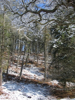
Wow. Time really does seem to be zooming along at the moment, I find it hard to believe that it’s already been over a week since my last post but the calendar is determined to prove otherwise. The weather on the other hand appears to have lost its calendar altogether and after careful consideration has decided that it's now winter. I was somewhat surprised therefore when I drew back my curtains on Sunday to find that someone had stolen my fine spring morning and replaced it with a winter wonderland. Still, on the plus side the sun was out and it wasn't raining for a change so I figured I might as well grab my rucksack, pull on the boots and go for a trundle around Cannock Chase.

I'm quite fond of Cannock Chase. Not only because it's a lovely place for a stroll that's right on my doorstep but also because I've been walking up at the Chase with my family since I was a kid. I remember my dad used to drag my brother and me for a ramble every Christmas Eve in a valiant but vain attempt to wear us out so that he and my mum could enjoy a bit of a lie-in come Christmas Day. Another family favourite is a short stroll from the Punch Bowl (car park in a little valley) to the stepping stones (speaks for itself really) which is only a couple of miles at most but has nonetheless been the Sunday afternoon walk of choice in our family for years. That being the case there was really only one place for me to tromp about amongst the snow and so I shrugged into my pack (it's slowly getting heavier as I acquire more gear though for the time being it's still quite acceptable) and set out along the usual trail.


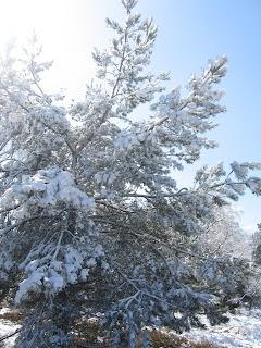
It was one of those walks where I didn't really have a plan, though a quick glance at the map provided me with a vague circuit of seven or eight miles which I figured would be ideal. I was quite content just to wander along at my own pace and enjoy the snow covered landscape before me. I found myself contemplating what exactly it was about snow that makes everyone into a budding photographer. There's no denying that a snowy scene can be exceedingly photogenic but after dodging around my forth camera tripod (conveniently set up in the middle of the path for maximum annoyance) I did begin to wonder whether I'd accidentally wandered into an outdoor photography convention. Such was my musing on the snow's appearance that I totally failed to spot the fact that it is also rather adept at concealing the various tracks and trails criss-crossing my route. This fact was hammered home rather effectively however when it suddenly occurred to me that I hadn't seen another person in about 20 minutes (the Chase is something of a magnet to outdoorsy types on a nice day) and whilst I wasn't lost I also had no idea where I was going. A hasty consultation of the map later, I had a plan to rejoin the trail.

I'd take the next path to the right and join up with the main road that I knew was running vaguely parallel to my route somewhere just out of sight (I could hear the occasional traffic quite clearly so I knew it was probably only a mile at most). I could then follow the road to the next junction where I could pick up another trail to take me along a winding stream and back into familiar territory. It started promisingly enough, the next path I took was wide, clear and most importantly heading in the right direction. Sadly said path also thought it would be amusing to lead me the brink of the road without a hitch and then dump me unceremoniously in an overgrown copse of trees. I wasted the next 20 minutes trying to find a way around the obstruction before finally losing patience and battering my way directly through the stubborn undergrowth whilst the snow from the branches above battered its way directly down the back of my shirt. It must be said that despite this little hiccup the rest of the walk went like clockwork. I found the next path a little further down the main road as I had expected and after a brief moment where I thought I had gone astray once again the little stream appeared from under its snowy blanket and led me all the way back to the stepping stones. Not a particularly strenuous walk really, but every mile I get in my boots makes them that little bit more comfortable which is going to pay dividends when I hit the trail for real.

Speaking of hitting the trail, I've now finally pinned down a start date for this little adventure after spending forever trying to find the best way to dodge around the bank holiday. I shall be setting off from Land's End on the 21st May with the hope of arriving in John O' Groats some 91 days later on the 19th August (though this will no doubt alter once I get under way). This gives me little over 5 weeks before the big day which is not much time at all given how the past week has flown by. It has however allowed me to add a bit more structure to my itinerary to the extent that I think it's ready for its first public appearance. What follows is my plan as it stands at the moment although until I stagger into John O Groats in August it should really be considered a work in progress. Still, it should give you some idea of where I will be and when, so if you fancy joining me for a day or two you'll know vaguely where to look.

Until next time folks.


LEJOG Itinerary

21/05 - Day 1: Land's End -> Penzance (9.5 mi)
22/05 - Day 2: Penzance -> Pengoon Farm (13.5 mi)
23/05 - Day 3: Pengoon Farm -> Carnon Downs (12.5 mi)
24/05 - Day 4: Carnon Downs -> Carnon Downs (0 mi)
25/05 - Day 5: Carnon Downs -> Trekenning (17 mi)
26/05 - Day 6: Trekenning -> St Breward (17.5 mi)
27/05 - Day 7: St Breward -> Five Lanes (12 mi)
28/05 - Day 8: Five Lanes -> Five Lanes (0 mi)
29/05 - Day 9: Five Lanes -> Roadford Lake (17 mi)
30/05 - Day 10: Roadford Lake -> Bridestowe (11.5 mi)
31/05 - Day 11: Bridestowe -> Venton (13 mi)
01/06 - Day 12: Venton -> Salmonhutch (12.5 mi)
02/06 - Day 13: Salmonhutch -> Salmonhutch (0 mi)
03/06 - Day 14: Salmonhutch -> Tiverton (13.5 mi)
04/06 - Day 15: Tiverton -> Taunton (20 mi)
05/06 - Day 16: Taunton -> Street (20 mi)
06/06 - Day 17: Street -> Radstock (18 mi)
07/06 - Day 18: Radstock -> Radstock (0 mi)
08/06 - Day 19: Radstock -> Bath (12 mi)
09/06 - Day 20: Bath -> Tomarton (13.5 mi)
10/06 - Day 21: Tomarton -> North Nibley (15 mi)
11/06 - Day 22: North Nibley -> Painswick (15.5 mi)
12/06 - Day 23: Painswick -> Cheltenham (11 mi)
13/06 - Day 24: Cheltenham -> Tewkesbury (10 mi)
14/06 - Day 25: Tewkesbury -> Tewkesbury (0 mi)
15/06 - Day 26: Tewkesbury -> Worcester (14 mi)
16/06 - Day 27: Worcester -> Stourport (14 mi)
17/06 - Day 28: Stourport -> Kinver (13 mi)
18/06 - Day 29: Kinver -> Brewood (18.5 mi)
19/06 - Day 30: Brewood -> Stafford (14.5 mi)
20/06 - Day 31: Stafford -> Stafford (0 mi)
21/06 - Day 32: Stafford -> Uttoxeter (15.5 mi)
22/06 - Day 33: Uttoxeter -> Fenny Bentley (14.5 mi)
23/06 - Day 34: Fenny Bentley -> Blackwell (16.5 mi)
24/06 - Day 35: Blackwell -> Edale (12 mi)
25/06 - Day 36: Edale -> Crowden (16 mi)
26/06 - Day 37: Crowden -> Crowden (0 mi)
27/06 - Day 38: Crowden -> Standedge (11 mi)
28/06 - Day 39: Standedge -> Hebden Bridge (17 mi)
29/06 - Day 40: Hebden Bridge -> Cowling (10 mi)
30/06 - Day 41: Cowling -> Malham (16 mi)
01/07 - Day 42: Malham -> Malham (0 mi)
02/07 - Day 43: Malham -> Horton (13 mi)
03/07 - Day 44: Horton -> Hawes (12.5 mi)
04/07 - Day 45: Hawes -> Keld (12.5 mi)
05/07 - Day 46: Keld -> Middleton (18.5 mi)
06/07 - Day 47: Middleton -> Langdon Beck (7.5 mi)
07/07 - Day 48: Langdon Beck -> Langdon Beck (0 mi)
08/07 - Day 49: Langdon Beck -> Dufton (12 mi)
09/07 - Day 50: Dufton -> Alston (19 mi)
10/07 - Day 51: Alston -> Greenhead (15 mi)
11/07 - Day 52: Greenhead -> Stonehaugh (14 mi)
12/07 - Day 53: Stonehaugh -> Bellingham (8 mi)
13/07 - Day 54: Bellingham -> Bellingham (0 mi)
14/07 - Day 55: Bellingham -> Cottonshopeburnfoot (13 mi)
15/07 - Day 56: Cottonshopeburnfoot -> Jedburgh (18.5 mi)
16/07 - Day 57: Jedburgh -> Melrose (16 mi)
17/07 - Day 58: Melrose -> Melrose (0 mi)
18/07 - Day 59: Melrose -> Innerleithen (18.5 mi)
19/07 - Day 60: Innerleithen -> Peebles (9 mi)
20/07 - Day 61: Peebles -> West Linton (15 mi)
21/07 - Day 62: West Linton -> Edinburgh (18.5 mi)
22/07 - Day 63: Edinburgh -> Edinburgh (0 mi)
23/07 - Day 64: Edinburgh -> Beecraigs (21.5 mi)
24/07 - Day 65: Beecraigs -> Beecraigs (0 mi)
25/07 - Day 66: Beecraigs -> Kilsyth (20 mi)
26/07 - Day 67: Kilsyth -> Drymen (20.5 mi)
27/07 - Day 68: Drymen -> Drymen (0 mi)
28/07 - Day 69: Drymen -> Rowardennan (14 mi)
29/07 - Day 70: Rowardennan -> Inverarnan (12.5 mi)
30/07 - Day 71: Inverarnan -> Tyndrum (10.5 mi)
31/07 - Day 72: Tyndrum -> Kingshouse (17 mi)
01/08 - Day 73: Kingshouse -> Kinlochleven (9 mi)
02/08 - Day 74: Kinlochleven -> Kinlochleven (0 mi)
03/08 - Day 75: Kinlochleven -> Fort William (15.5 mi)
04/08 - Day 76: Fort William -> South Laggan (19 mi)
05/08 - Day 77: South Laggan -> Invermoriston (14 mi)
06/08 - Day 78: Invermoriston -> Invermoriston ( 0 mi)
07/08 - Day 79: Invermoriston -> Drumnadrochit (14 mi)
08/08 - Day 80: Drumnadrochit -> Inverness (19 mi)
09/08 - Day 81: Inverness -> Inverness (0 mi)
10/08 - Day 82: Inverness -> Dingwall (15.5 mi)
11/08 - Day 83: Dingwall -> Alness (9 mi)
12/08 - Day 84: Alness -> Dornoch (20 mi)
13/08 - Day 85: Dornoch -> Dornoch (0 mi)
14/08 - Day 86: Dornoch -> Brora (19 mi)
15/08 - Day 87: Brora -> Helmsdale (10 mi)
16/08 - Day 88: Helmsdale -> Dunbeath (15 mi)
17/08 - Day 89: Dunbeath -> Dunbeath (0 mi)
18/08 - Day 90: Dunbeath -> Wick (21 mi)
19/08 - Day 91: Wick -> John O' Groats (17.5 mi)